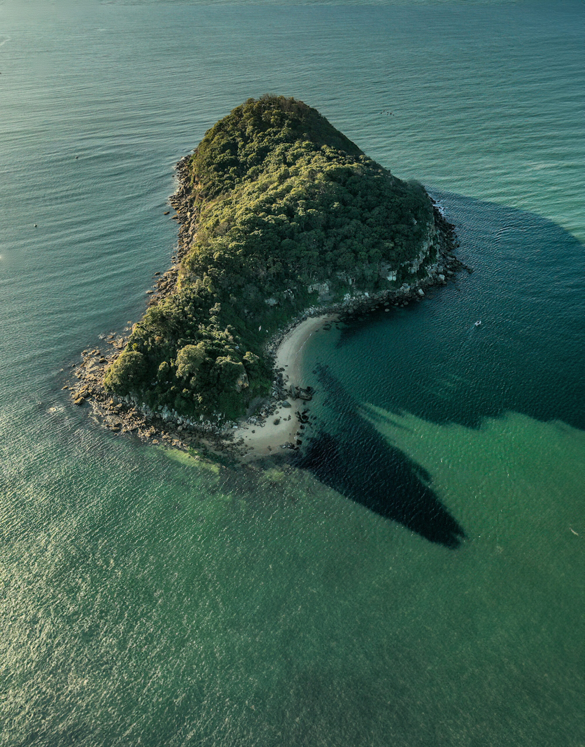
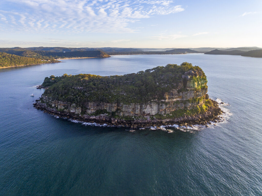
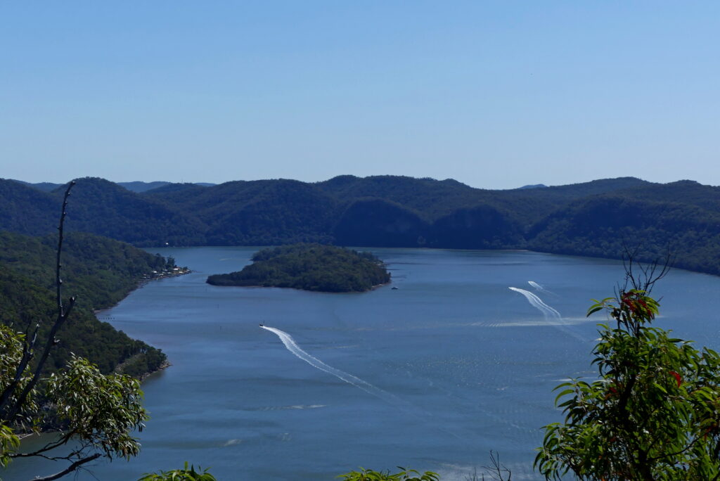
LION ISLAND
Characteristics: Without a doubt, this is our most recognisable island because of its distinctive sphinx-like profile. Crouched at the mouth of the Hawkesbury River in Broken Bay, it can be seen from Sydney’s Northern Beaches and Pittwater suburbs as well as from any number of the Central Coast’s southern-most beaches and headlands. The island was formed from Hawkesbury sandstone at its eastern cape, and older Narrabeen sandstone and shale along its shores. Today, it is a nature reserve administered by the NSW National Parks & Wildlife and is a protected habitat for a 300-strong colony of little penguins.
Size: 8.1 hectares.
History: Governor Arthur Phillip named it Mount Elliot Island in 1789 because he thought it looked similar to Gibraltar where General Elliott had defeated the French and Spanish fleets. The name continued to be used until the 1920s.
Why you’d visit: This is an island that most of us probably wouldn’t visit because it’s not accessible other than with a permit for conservation, education or research purposes.
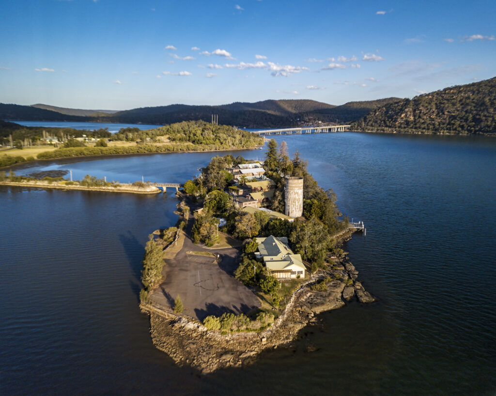
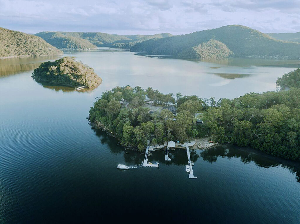
DANGAR ISLAND
Characteristics: The Riverboat Postman still delivers the mail here and you can travel by ferry from Brooklyn, or by private boat or water taxi. The island provides idyllic island-living to a population of 313 people and is also home to over 100 animal species. There are no cars on the island but watch out for bicycles and wheelbarrows.
Size: 30.8 hectares.
History: Governor Phillip named it Mullet Island because of the abundant mullet fish his exploration party caught there. It was classified as Crown Land in 1794, after which Andrew Thompson leased the island and established salt boilers. In 1864, pastoralist and politician Henry Dangar bought the island for £1 and named it after himself. In 1886, when the railway bridge across the Hawkesbury was being built, the Union Bridge Company leased the island for three years. After Henry Dangar’s death, his son sold the island and it was subdivided in 1921.
Why you’d visit: Walk the 4 km loop around the local streets, view the Indigenous rock engravings, caves and middens, spot the rare blackbutt rough-barked apple forest in Kiparra Park Reserve and take the walking track to the summit for great views of the river. The Dangar Island Depot beside the ferry wharf is open for all-day breakfast and lunch and the bowling club is open Thursday to Saturday for dinner and lunch on Sundays. You can also escape mainland life and stay overnight in one of the island’s Airbnbs.

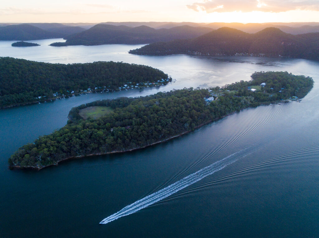
LONG ISLAND
Characteristics: The island is part of the railway causeway which joins it to the mainland and across Sandbrook Inlet. It’s recognised as part of Brisbane Water National Park.
Size: 73 hectares and is 2 km long.
History: Inhabited for thousands of years by local Indigenous peoples who have left their mark with hundreds of rock engravings, cave paintings, middens and stone sharpening grooves. In 1829, the government surveyor WR Govett gave it its European name. In 1911, it was designated a recreation reserve, used mainly by anglers and, in 1972, was upgraded to a nature reserve.
Why you’d visit: NSW Parks & Wildlife run occasional guided tours, but at all other times you will require a permit from the Office of Environment and Heritage.
SPECTACLE ISLAND
Characteristics: Located at the junction of Mooney Mooney Creek and the Hawkesbury, it was listed on the Register of the National Estate in 1978 and, in 2006, was added to the Australian National Heritage List as an important remnant of the Central Coast’s natural environment, diverse vegetation and abundance of Indigenous sites. It is considered part of the Brisbane Water National Park. It has some small sandy beaches, mudflats and rocks as well as mangroves and thick vegetation.
Size: 36.4 hectares.
History: For some reason, domestic animals tended to get marooned on this island, including a legendary hungry cow that resorted to eating a fisherman’s catch of flatheads. The island’s European name was originally Goat Island after the herd of animals that also lived there. It was later named Spectacle Island, possibly for its spectacular views.
Why you’d visit: Come by boat to explore the protected nature reserve precinct, enjoy spotting the local wildlife and the interesting Aboriginal rock art. It’s a peaceful place with great views from its tall summit.
SNAKE ISLAND
Characteristics: Located near the mouth of Mooney Mooney Creek off Cheero Point. In spite of the inhospitable name, you can land on a small sandy beach and explore the shoreline. Inland is much less accessible with steep rocky terrain, thick vegetation and no discernible walking tracks.
Size: Very small, an islet.
Why you’d visit: If you’re out for a paddle on your kayak, it’s a nice little resting place.
MILSON ISLAND
Characteristics: Separated by Milsons Passage from the northern shore of the Hawkesbury River, the island is accessible by ferry from Kangaroo Point and Brooklyn. The Riverboat Postman delivers the mail. The island houses a Sport and Recreation Centre for school holiday camps as well as for community and corporate groups. It has well-kept lawns and landscaped gardens, a 25-metre swimming pool and playground.
Size: The island seems to be measured in terms of the number of people it can accommodate: 170 in seven dormitory-style lodges and 30 in five self-contained holiday units.
History: It was known as Mud Island during the 1800s, probably because of the extensive mud bank at one end of the island. It was given in an early land grant to an Aboriginal woman, Sarah Lewis Ferdinand, who was married to a German convict. She was known as Biddy and later as Granny Lewis, and became the matriarch of a large group of Aboriginal and local pioneers. In 1865, her land was bought by Robert Milson who lived on the mainland between the island and Kangaroo Point until he died in 1886. The island was purchased by the NSW Government in 1901. It has been used as a bacteriological station, quarantine station, a hospital to treat World War I soldiers with venereal disease, a mental hospital, a rehabilitation centre for ‘inebriates’, a women’s jail and as a river trading post. The furnishings from the asylum still remain.
Why you’d visit: It is a popular place for school camps with a wide range of activities including kayaking, canoeing, archery, bushwalking, abseiling, swimming and rock climbing.
PEAT ISLAND / KOOROOWALL-UNDI
Characteristics: Located just west of the Pacific Motorway (M1), the island is connected to the mainland by a rubble causeway and bridge. It has open grasslands, a foreshore walk and reminders of its harsh past in the collection of disused buildings.
Size: 8 hectares.
History: In the 1800s, Peat was known as Rabbit Island when it was ‘stocked as a rabbit warren’ with rabbits considered a good source of food for nearby farms and ‘genteel residences’. In 1936, it was renamed after George Peat, an early settler and boat builder who, in 1844, had established the first ferry across the Hawkesbury between Mooney Mooney and Kangaroo Point.
In 1900, the NSW Government passed legislation to establish an asylum for ‘inebriates’ and Peat Island housed alcoholics until 1911 when the facility became a hospital for insane men and boys. It was a harsh place, and press reports at the time document drownings and unexplained deaths with at least 300 patients mysteriously dying during their time there. The hospital was decommissioned as late as 2010 and, in 2022, the NSW Government handed the island over to
the Darkinjung Local Aboriginal Land Council.
Why you’d visit: The island is not yet open to the general public, partly for reasons of safety because of the number of condemned buildings and hazardous materials. The Land Council is considering ways to best recognise and preserve the island’s rich Aboriginal heritage as well as paying respect to the island’s terrible history of institutional use.
BAR ISLAND
Characteristics: Located at the mouth of Berowra Creek, it is the western-most of the islands shown here. Although uninhabited because of the lack of water, it is a good example of the local flora and fauna and is home to the threatened glossy black cockatoo and to whistling kites.
Size: 3.8 hectares.
History: It was a meeting place for Dharug clans and retains strong evidence of early Aboriginal use. Governor Phillip was said to have visited on his second exploration of the Hawkesbury in 1789. At one time the island was also known as Goville Island. The name, Bar Island, was in use during the 1800s, probably in recognition of a hazardous shoal between the island and Bar Point. In the 1870s, the island was a focal point for local communities and housed St John’s Church, a school and a cemetery. The church was demolished in 1892 after a severe storm but the stone fireplace and chimney (made from stone brought from George Peat’s home in Mooney Mooney) are still evident today.
Why you’d visit: Only accessible by private boat or water taxi, the island is well worth a visit. View the Aboriginal shell middens and historic sites and walk the Heritage Trail. The cemetery’s unmarked graves have interesting histories. Among those buried on the island are Granny Lewis in 1880 (see Milson Island); a three-week old baby, Maude Lloyd, for whose mother Henry Kendall wrote the poem, On a Baby Buried by the Hawkesbury; the convict James Calvert who died in 1880 at Brisbane Water but was buried on the island, as was his wife (1883); and Robert Milson in 1865 (see Milson Island).
In the next issue of COAST: The islands of Brisbane Water, Tuggerah Lake, Lake Macquarie and our offshore islands.